North Bengkulu Regency
North Bengkulu Regency
Kabupaten Bengkulu Utara | |
|---|---|
 | |
| Motto(s): Bersatu Bekerja Berdoa Berhasil (Unite Work Pray Success) | |
 | |
| Coordinates: 3°20′00″S 102°03′00″E / 3.3333°S 102.0500°E | |
| Country | |
| Province | Bengkulu |
| Regency seat | Arga Makmur |
| Area | |
• Total | 4,424.60 km2 (1,708.35 sq mi) |
| Population (mid 2023 estimate)[1] | |
• Total | 306,659 |
| • Density | 69/km2 (180/sq mi) |
| Time zone | UTC+7 (WIB) |
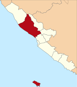
North Bengkulu is a regency (Indonesian: kabupaten) of Bengkulu Province, Indonesia, on the island of Sumatra. It originally covered much of the northern part of Bengkulu Province, but on 25 February 2003 the most northwesterly districts were split off to form a separate Mukomuko Regency (Kabupaten Mukumuko), and on 24 June 2008 the most southeastern districts were likewise split off to create a new Central Bengkulu Regency (Kabupaten Bengkulu Tengah).
The residual regency now covers an area of 4,424.60 km2, and it had a population of 257,675 at the 2010 Census[2] and 296,523 at the 2020 Census;[3] the official estimate as at mid 2023 was 306,659 (comprising 156,720 males and 149,939 females).[1] The administrative centre is at the town of Arga Makmur.
Administrative districts
[edit]At the 2010 Census the Regency was divided into twelve districts (Indonesian: kecamatan), but subsequently seven additional districts have been created by the splitting of existing ones. The nineteen districts are detailed below with their areas and populations at the 2010 Census[2] and the 2020 Census,[3] together with the official estimates as at mid 2023.[1] The table also includes the locations of the district administrative centres, the number of administrative villages in each district (a total of 215 rural desa and 5 urban kelurahan), and its post code.
| Kode Wilayah |
Name of District (kecamatan) |
Area in km2 |
Pop'n 2010 Census |
Pop'n 2020 Census |
Pop'n mid 2023 Estimate |
Admin centre |
No. of villages |
Post code |
|---|---|---|---|---|---|---|---|---|
| 17.03.01 | Enggano (a) (island) |
400.60 | 2,691 | 4,035 | 4,502 | Apoho | 6 | 38387 |
| 17.03.06 | Kerkap | 93.65 | 22,874 | 12,423 | 12,705 | Lubuk Durian | 18 (b) | 38379 |
| 17.03.16 | Air Napal | 156.00 | 11,523 | 9,791 | 10,133 | Pasar Tebat | 12 | 38373 |
| 17.03.15 | Air Besi | 47.75 | 10,323 | 9,747 | 10,128 | Dusun Curup | 15 | 38575 |
| 17.03.19 | Hulu Palik | 74.50 | (c) | 11,232 | 11,570 | Taba Padang Kol | 15 | 38374 |
| 17.03.22 | Tanjung Agung Palik | 53.00 | (c) | 8,020 | 8,311 | Tanjung Agung Palik | 10 | 38576 |
| 17.03.07 | Kota Arga Makmur | 32.00 | 47,457 | 42,362 | 43,608 | Gunung Agung | 16 (d) | 38611 - 38619 |
| 17.03.21 | Arma Jaya | 68.00 | (c) | 12,577 | 13,274 | Sumber Agung | 12 (e) | 38611 |
| 17.03.10 | Lais | 67.50 | 17,195 | 13,599 | 14,099 | Pal 30 | 13 (f) | 38654 |
| 17.03.11 | Batik Nau | 81.50 | 11,727 | 13,599 | 13,482 | Samban Jaya | 15 | 38656 |
| 17.03.08 | Giri Mulya | 86.25 | 13,135 | 15,037 | 15,514 | Giri Mulya | 6 | 38655 |
| 17.03.20 | Air Padang | 162.75 | (c) | 6,385 | 6,610 | Kembang Manis | 10 | 38653 |
| 17.03.09 | Padang Jaya | 531.00 | 27,397 | 31,928 | 33,112 | Padang Jaya | 12 | 38657 |
| 17.03.12 | Ketahun | 134.37 | 39,704 | 21,054 | 22,500 | Pasar Ketahun | 11 | 38361 |
| 17.03.13 | Napal Putih | 700.63 | 17,582 | 8,527 | 9,016 | Napal Putih | 10 | 38363 |
| 17.03.23 | Uluk Kupai | 520.10 | (c) | 13,153 | 13,839 | Tanjung Dalam | 10 | 38364 |
| 17.03.24 | Pinang Raya | 234.00 | (c) | 23,464 | 23,292 | Sumber Mulya | 10 | 38362 |
| 17.03.14 | Putri Hijau (g) | 188.50 | 36,067 | 23,659 | 23,917 | Pasar Baru Kota Bani | 9 | 38326 |
| 17.03.25 | Marga Sakti Sebelat | 792.50 | (c) | 16,383 | 17,047 | Suka Baru | 10 | 38325 |
| Totals | 4,424.60 | 257,675 | 296,523 | 306,659 | Arga Makmur | 220 |
Notes: (a) Besides Enggano Island (Pulau Enggano) in the Indian Ocean, the district includes four small islands off its coast - Pulau Dua, Pulau Merbau, Pulau Bangkai and Pulau Satu. (b) including the kelurahan of Lubuk Durian.
(c) the 2010 population of these new districts (established since 2010) are included in the figures for the districts from which they were split off.
(d) including the two kelurahan of Gunung Alam and Purwodadi. (e) including the kelurahan of Kemunu. (f) including the kelurahan of Pasar Lais.
(g) includes Mega Island (Pulau Mega) - like Enggano Island, this is a small barrier island roughly halfway between Enggano and South Pagai Island of West Sumatra.
References
[edit]External links
[edit]![]() Media related to North Bengkulu Regency at Wikimedia Commons
Media related to North Bengkulu Regency at Wikimedia Commons


