Chelsea, Quebec
Chelsea | |
|---|---|
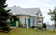
 Old Chelsea | |
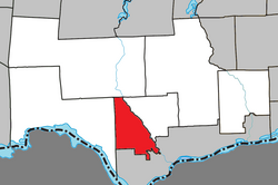
 Location within Les Collines-de-l'Outaouais RCM | |
| Coordinates: 45°30′N 75°47′W / 45.500°N 75.783°W[1] | |
| Country | Canada |
| Province | Quebec |
| Region | Outaouais |
| RCM | Les Collines-de-l'Outaouais |
| Constituted | January 1, 1875 |
| Government | |
| • Mayor | Pierre Guénard |
| • Federal riding | Pontiac |
| • Prov. riding | Gatineau |
| Area | |
• Total | 121.10 km2 (46.76 sq mi) |
| • Land | 113.77 km2 (43.93 sq mi) |
| Population (2021)[4] | |
• Total | 8,000 |
| • Density | 71.0/km2 (184/sq mi) |
| • Pop 2016-2021 | |
| • Dwellings | 3,376 |
| Time zone | UTC−5 (EST) |
| • Summer (DST) | UTC−4 (EDT) |
| Postal code(s) | |
| Area code | 819 |
| Highways | |
| Website | www |
Chelsea is a municipality located immediately north of Gatineau, Quebec, Canada, and about 10 kilometres (6.2 mi) north of Ottawa. Chelsea is located within Canada's National Capital Region. It is the seat of Les Collines-de-l'Outaouais Regional County Municipality.[5]
Its population was 8000 in the 2021 Canadian Census.[6] The population of Chelsea is almost evenly divided between anglophones and francophones, with both official languages being spoken in roughly 70% of households.[7]
The municipality has a reputation for being environmentally responsible,[citation needed] and was one of the first in Canada to ban the use of pesticides. While 60% of the area consists of Gatineau Park, much of the rest of Chelsea is residential.
A sports complex, the Meredith Centre, was developed in 2012 next to Chelsea Elementary School. The complex hosts a hockey rink, community rooms, and soccer fields.[8] The mayor of Chelsea, QC is Pierre Guénard.[9]
Part of the film Grey Owl was shot on the Gatineau River. A number of regionally and nationally well-known[citation needed] musicians, filmmakers, and artists live in Chelsea, including Ian Tamblyn.
Geography
[edit]Chelsea is a roughly triangle-shaped municipality that includes much of the southern and eastern parts of Gatineau Park, and is bordered on the east by the Gatineau River. The southern border is 5 kilometres (3.1 mi) south of Old Chelsea, the municipality historical centre, and runs north to the community of Farm Point. Beyond Farm Point lies the municipality of La Pêche and the village of Wakefield. North of Old Chelsea is Camp Fortune, a popular alpine ski club 15 minutes from Downtown Ottawa.
Communities
[edit]- Kingsmere
- Chelsea
- Old Chelsea
- Larrimac
- Farm Point
- Hollow Glen
History
[edit]Chelsea is named after the Vermont town of its first settler, Thomas Brigham, who was a partner and son-in-law of Philemon Wright and arrived there in 1819. The name has been in use since the early 19th century: Old Chelsea (1819), Parish Saint-Stephen-of-Chelsea (1835), Chelsea (circa 1870). In 1875, the municipality was established as Hull-Partie-Ouest, or commonly referred to as West Hull. The municipality was renamed to its current name in 1990.[1]
During World War II, the Royal Canadian Navy wanted to understand more about the propagation of radio waves and how they were affected by the earth's ionosphere so that German radio transmissions could be intercepted more efficiently. In cooperation with the National Research Council, the RCN established a "field intensity station" at Chelsea in 1941 to monitor the height of the ionosphere.
Chelsea, also known as an ionospheric observatory, was established in 1941 and closed down in 1947. It was located on the north side of Old Chelsea Road a few hundred yards west of Highway 105. The Chelsea station operated during the post-war period but in 1947, its work was transferred to the Defence Research Board's new Radio Propagation Laboratory in Ottawa. Shortly thereafter, the station was demolished. Today, there are no traces of the single shack or the many masts that were once erected on the property.[10]
Demographics
[edit]| Year | Pop. | ±% |
|---|---|---|
| 1976 | 3,489 | — |
| 1981 | 3,546 | +1.6% |
| 1986 | 3,908 | +10.2% |
| 1991 | 5,091 | +30.3% |
| 1996 | 5,925 | +16.4% |
| 2001 | 6,036 | +1.9% |
| 2006 | 6,703 | +11.1% |
| 2011 | 6,977 | +4.1% |
| 2016 | 6,909 | −1.0% |
| 2021[4] | 8,000 | +15.8% |
| Source: Statistics Canada | ||
| 2021 | 2016 | 2011 | |
|---|---|---|---|
| Population | 8,000 (+15.8% from 2016) | 6,909 (-1.0% from 2011) | 6,977 (4.1% from 2006) |
| Land area | 112.65 km2 (43.49 sq mi) | 113.77 km2 (43.93 sq mi) | 113.40 km2 (43.78 sq mi) |
| Population density | 71/km2 (180/sq mi) | 60.7/km2 (157/sq mi) | 61.5/km2 (159/sq mi) |
| Median age | 43.6 (M: 44.4, F: 42.4) | 44.8 (M: 45.6, F: 44.1) | 42.3 (M: 42.9, F: 41.8) |
| Private dwellings | 3,376 (total) 3,041 (occupied) | 2,898 (total) | 2,956 (total) |
| Median household income | $146,000 | $116,443 | $108,629 |
Mother tongue:[4]
- English as first language: 43.1%
- French as first language: 46.3%
- English and French as first language: 3.9%
- Other as first language: 5.6%
Transportation
[edit]Autoroute 5, also known as the Autoroute de la Gatineau, is a major freeway that connects Chelsea and La Pêche with Gatineau and Ottawa.
Public transportation is provided to the region by Transcollines, with bus routes 921, 922, 923, 924, and 925 connecting the regional county municipality with Gatineau as of 2022.[16] During summer weekends, the Societé de Transport de l'Outaouais provides free shuttle buses through Gatineau Park that terminate at the Gatineau Park Visitors Centre in Old Chelsea.[17]
Gallery
[edit]-
Chelsea town hall in Old Chelsea, which is also the home of the Chelsea Library's main branch.
-
The administrative center and municipal court of Les Collines-de-l'Outaouais RCM is located in Chelsea.
-
The Chelsea Creek flows southeast through Old Chelsea, eventually forming part of the southern border with Gatineau.
See also
[edit]References
[edit]- ^ a b "Banque de noms de lieux du Québec: Reference number 258615". toponymie.gouv.qc.ca (in French). Commission de toponymie du Québec.
- ^ a b "Répertoire des municipalités: Geographic code 82025". www.mamh.gouv.qc.ca (in French). Ministère des Affaires municipales et de l'Habitation.
- ^ "Chelsea, Quebec (Code 2482025) Census Profile". 2016 census. Government of Canada - Statistics Canada.
- ^ a b c "Chelsea, Quebec (Code 2482025) Census Profile". 2021 census. Government of Canada - Statistics Canada.
- ^ "About MRC". MRC des Collines-de-l'Outaouais. Retrieved 2023-02-01.
- ^ Government of Canada, Statistics Canada (2022-02-09). "Profile table, Census Profile, 2021 Census of Population - Chelsea, Municipalité (MÉ) [Census subdivision], Quebec". www12.statcan.gc.ca. Retrieved 2022-08-03.
- ^ Government of Canada, Statistics Canada (2022-07-13). "Focus on Geography Series, 2021 Census - Chelsea (Census subdivision)". www12.statcan.gc.ca. Retrieved 2023-02-01.
- ^ "The Meredith Centre". Centre Meredith. Retrieved 2024-04-03.
- ^ "Council and Committees". Municipalité de Chelsea. Retrieved 2023-01-31.
- ^ Studio, Tonik Web. "History | Municipality of Chelsea". Municipalité de Chelsea. Retrieved 2023-02-01.
- ^ "2021 Community Profiles". 2021 Canadian census. Statistics Canada. February 4, 2022. Retrieved 2023-10-19.
- ^ "2016 Community Profiles". 2016 Canadian census. Statistics Canada. August 12, 2021. Retrieved 2019-12-11.
- ^ "2011 Community Profiles". 2011 Canadian census. Statistics Canada. March 21, 2019. Retrieved 2019-12-11.
- ^ "2006 Community Profiles". 2006 Canadian census. Statistics Canada. August 20, 2019.
- ^ "2001 Community Profiles". 2001 Canadian census. Statistics Canada. July 18, 2021.
- ^ "Public transportation – Transcollines". Retrieved 2022-09-04.
- ^ "Gatineau Park shuttle". NCC-CCN. Retrieved 2022-09-04.


