Colorado River Indian Tribes
 Tribal flag | |
| Total population | |
| 4,277[1] | |
| Regions with significant populations | |
( | |
| Languages | |
| Colorado River Numic language, Mojave, Navajo, Hopi, English | |
| Related ethnic groups | |
| other Mohave, Chemehuevi, Hopi, and Navajo people |
The Colorado River Indian Tribes (Mohave: Aha Havasuu, Navajo: Tó Ntsʼósíkooh Bibąąhgi Bitsįʼ Yishtłizhii Bináhásdzo) is a federally recognized tribe consisting of the four distinct ethnic groups associated with the Colorado River Indian Reservation: the Mohave, Chemehuevi, Hopi, and Navajo. The tribe has about 4,277 enrolled members. A total population of 9,485 currently resides within the tribal reservation according to the 2012-2016 American Community Survey data.[2]
History
[edit]The reservation was established on March 3, 1865, for "Indians of said river and its tributaries."[3] Initially, these were the Mohave and Chemehuevi, but Hopi and Navajo people were relocated to the reservation in 1945.[4] In 1942, land within the reservation was chosen - against the wishes of the tribal council - as the site of Poston War Relocation Center during World War II. Office of Indian Affairs officials saw the Japanese-American Internment camp as a way to bring infrastructure to the reservation without having to fund it themselves. The camp closed in 1945 and the land and remaining camp buildings was returned to the tribes.[5][6] John Scott designed the tribal seal in 1966, with four feathers to represent the four CRIT tribes (Colorado River indian Tribes). Margie McCabe designed the tribal flag, which the tribe formally adopted in 1979.[1]
Reservation
[edit]
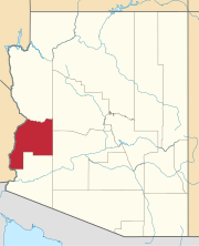
The Colorado River Indian Reservation is a Native American reservation in the southwest United States. Its territory is primarily in western La Paz County, Arizona, with smaller portions in southeastern San Bernardino,[4] and northeastern Riverside counties, California. It has a total land area of 1,119.4445 km2 (432.22 sq mi), most of it within Parker Valley. It borders the Palo Verde Valley in the southwest boundaries. Tribal headquarters are in Parker, Arizona. Tribal members mainly live in communities in and around Parker, the largest community, and Poston.[1] The 2000 census reported a population of 9,201 persons residing on the reservation.
Government
[edit]
The tribe and its reservation territory are governed by an elected council of nine members and overseen by a tribal Chairman, Secretary, and Treasurer. These officers are elected from among the council members. The four tribes continue to maintain and observe their traditional ways and religious and culturally unique identities.
The current administration is:
- Chairwoman: Amelia Flores
- Vice-Chairman: Dwight Lomayesva
- Tribal Secretary: Johnson "JD" Fisher
- Tribal Treasurer: Josephine Tahbo
- Council Member: Thomas "Tommy" Drennan
- Council Member: William “Billy” Beeson
- Council Member: Anisa Patch
- Council Member: Jaymee Moore
- Council Member: Robert "Bobby" Page
Economic development
[edit]


The economy for the tribe is based on light industry, government, recreation, and agricultural, specifically growing commodity crops of alfalfa, cotton, lettuce, and sorghum.[4] The Colorado River Indian Tribes (CRIT) has senior water rights to divert up to 719,248 acre feet of water from the Colorado River, which represents nearly one-third of the allocation for the state of Arizona.
The tribe operates BlueWater Resort and Casino, located about two miles (3 km) from downtown Parker, as a tourist destination on the Colorado River.[1] It opened in June 1999. The casino is 30,000 square feet (2,800 m2) and has more than 500 slot machines. The resort features a 200-room hotel, a 10,000 square feet (930 m2) bingo hall, an indoor water park, movie theater, video arcade, marina, and concert facilities.[7]
The Colorado River Indian Tribe Museum and Gift Shop is in Parker, Arizona,[8] and has displays of historical and contemporary artworks, especially ceramics, made by tribal members.
Communities
[edit]- Bluewater, Arizona
- Bluewater, California
- Parker, Arizona (seat of government)
- Poston, Arizona
Notable tribal members
[edit]- Jacoby Ellsbury (b. 1983), baseball center fielder with the Boston Red Sox and New York Yankees of Major League Baseball
- Veronica Murdock (born 1944), tribal vice chair and first woman president of the National Congress of American Indians
See also
[edit]Notes
[edit]- ^ a b c d "About the Mohave, Chemehuevi, Hopi and Navajo Tribes". Colorado River Indian Tribes. Retrieved November 22, 2015.
- ^ "My Tribal Area".
- ^ Fletcher, Alice Cunningham (1888). Congressional Serial Set. Washington, DC: U.S. Government Printing Office. p. 199.
- ^ a b c "Colorado River Indian Tribes". Inter Tribal Council of Arizona. Retrieved November 22, 2015.
- ^ Fujita-Rony, Thomas Y. "Poston (Colorado River)". Densho Encyclopedia. Archived from the original on August 7, 2014. Retrieved August 7, 2014.
- ^ Burton, Jeffery; Farrell, Mary; Kashima, Tetsuden; Lord, Richard (2003). Confinement and Ethnicity: An Overview of World War II Japanese American Relocation Sites. Seattle: University of Washington Press. p. 215.
- ^ http://tribalgovernmentgaming.com/listing/bluewater-resort-casino [dead link]
- ^ "CRIT Museum & Gift Shop". Colorado River Indian Tribes. Retrieved November 22, 2015.
References
[edit]- Colorado River Reservation, Arizona/California United States Census Bureau
External links
[edit]- 1865 establishments in the United States
- American Indian reservations in Arizona
- American Indian reservations in California
- Chemehuevi
- Colorado River Indian Tribes
- Colorado River tribes
- Communities in the Lower Colorado River Valley
- Federally recognized tribes in the United States
- Geography of La Paz County, Arizona
- Geography of San Bernardino County, California
- Hopi
- Lower Colorado River Valley
- Mohave
- Navajo
- Native American tribes in Arizona
- Native American tribes in California
- Native American tribes in Riverside County, California
- California populated places on the Colorado River
- Arizona populated places on the Colorado River


