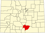
Badito, Colorado
Badito, Colorado | |
|---|---|
 Ruins in Badito, May 2007 | |
| Coordinates: 37°43′38″N 105°00′51″W / 37.7272°N 105.0142°W[2] | |
| Country | |
| State | |
| County | Huerfano[1] |
| Elevation | 6,431 ft (1,960 m) |
| Time zone | UTC−07:00 (MST) |
| • Summer (DST) | UTC−06:00 (MDT) |
| GNIS feature ID | 192690 |
Badito is a historic ghost town along the Huerfano River in Huerfano County, Colorado, United States.[2] "Huerfano" is a Spanish language noun meaning "orphan". Badito is located at the intersection of Colorado State Highway 69 and County Road 520.
History
[edit]

The long-abandoned community, located at the crossing of the Huerfano River, marks a path used by the Ancestral Puebloans during the Basketmaker era.
A Spanish expedition led by General Juan de Ulibarrí is the first known recorded journey through Badito. He documented the journey through Cuchara Pass, west of the Spanish Peaks in 1706. Juan de Ulibarrí's command reached the Rio de San Juan Baptista (currently named the Huerfano River) at Badito.
In 1819, Jacob Fowler noted an abandoned Spanish adobe fort at the location. Later, the Taos Trappers Trail, joining the Santa Fe Trail with the Cherokee Trail, passed through this location.
On February 28, 1861, Territory of Colorado was organized.[3] The Little Orphan, Colorado Territory, post office opened on May 1, 1865, but the name was changed to Badito on September 12 of that year.[4] Badito served as the seat of Huerfano County, Colorado Territory, from 1868 until 1874, when the county seat moved to Walsenburgh.[5][6] Colorado became a state on August 1, 1876.[7] The Badito, Colorado, post office finally closed on November 15, 1910.
See also
[edit]- Bibliography of Colorado
- Geography of Colorado
- History of Colorado
- Index of Colorado-related articles
- List of Colorado-related lists
- Outline of Colorado
References
[edit]- ^ "Colorado Counties". Colorado Department of Local Affairs. Retrieved December 31, 2024.
- ^ a b c "Badito, Colorado". Geographic Names Information System. United States Geological Survey, United States Department of the Interior. Retrieved December 31, 2024.
- ^ Thirty-sixth United States Congress (February 28, 1861). "An Act To provide a temporary Government for the Territory of Colorado" (PDF). Library of Congress. Retrieved December 23, 2024.
- ^ Bauer, William H.; Ozment, James L.; Willard, John H. (1990). Colorado Post Offices 1859–1989. Golden, Colorado: Colorado Railroad Historical Foundation. ISBN 0-918654-42-4.
- ^ "Colorado County History". COGenWeb Project. April 29, 2011. Archived from the original on July 23, 2008. Retrieved July 21, 2021.
- ^ Stanwyck, Don; Zion, Lee (2003). "Colorado County Evolution". COGenWeb Project. Retrieved October 12, 2024.
- ^ Ulysses S. Grant (August 1, 1876). "Proclamation 230—Admission of Colorado into the Union". The American Presidency Project. Retrieved December 24, 2024.
Further reading
[edit]- Whiteley, Lee. (1999). The Cherokee Trail: Bent's Old Fort to Fort Bridger. Boulder, Colorado: Johnson Printing. ISBN 0-9671351-1-7
- Historic Marker #13. Posted by the Territorial Daughters of Colorado, Badito, Colorado.
- Juan de Ulibarrí. Juan de Ulibarrí's Diary. Translated and posted by the Territorial Daughters of Colorado.
- McKenna, Thomas (2023) True Southern Colorado;Gateway to the American Southwest. Pages 165-170. Posted by Thomas McKenna, KDP Publishing BOBp9wrg38


