Jebel Shams
| Jabal Shams | |
|---|---|
 | |
| Highest point | |
| Elevation | 3,018 m (9,902 ft)[1] |
| Prominence | 2,818 m (9,245 ft) |
| Listing | Country high point Ultra |
| Coordinates | 23°14′13″N 57°15′50″E / 23.23694°N 57.26389°E |
| Naming | |
| Native name | جَبَل شَمْس (Arabic) |
| English translation | Mountain of Sun |
| Geography | |
| Location | |
| Parent range | Al-Hajar Mountains |
| Climbing | |
| Easiest route | (to South Summit) W4 route published by Ministry or Tourism, Oman (Grade 2 / 3)[2] |
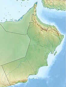
Jabal Shams or Jebel Shams (Arabic: جَبَل شَمْس, lit. 'Mountain of Sun') is a mountain located in northeastern Oman north of the town of Al-Hamra.
It is the highest mountain in Oman, and is part of the Jebel Akhdar or Jabal Akhdar Mountains,[3] which in turn belongs to the Hajar range.[4] The mountain is a popular sightseeing area located 240 km (150 miles) from Muscat.
It is known as Jabal Shams because it is the first place to receive sunrise in Oman due to its high peak.
In the summer, the temperature is around 20 °C (68 °F) and in the winter it drops to less than 0 °C (32 °F).[original research?] Jabal Shams also hosts Al Nakhur Canyon which is labeled as the Grand Canyon of Arabia.
Description
[edit]The highest point of the mountain is the North Summit, which is occupied by a military base and is a restricted area. The Ministry of Tourism, Sultanate of Oman, states the North Summit to be 3,009 m (9,872 ft) high.[4]
The mountain also has a second summit, the South Summit, which is publicly accessible for trekking via the W4 Trail,[5] marked by the Oman Ministry of Tourism.[2] The elevation of the second south summit is 2,997 m (9,833 ft).[5]
-
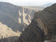
A view from the top
-
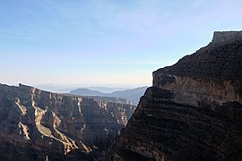
Jebel Shams Balcony Walkway
-
View from the Balcony Walkway
-
The 'Grand Canyon' of the Middle East
Climate
[edit]| Climate data for Jebel Shams, elevation 2,764 m (9,068 ft), (2005–2017 normals) | |||||||||||||
|---|---|---|---|---|---|---|---|---|---|---|---|---|---|
| Month | Jan | Feb | Mar | Apr | May | Jun | Jul | Aug | Sep | Oct | Nov | Dec | Year |
| Mean daily maximum °C (°F) | 8.5 (47.3) |
9.9 (49.8) |
12.9 (55.2) |
16.1 (61.0) |
19.4 (66.9) |
21.9 (71.4) |
22.0 (71.6) |
20.8 (69.4) |
18.9 (66.0) |
15.3 (59.5) |
11.1 (52.0) |
8.7 (47.7) |
15.5 (59.8) |
| Daily mean °C (°F) | 5.0 (41.0) |
5.9 (42.6) |
8.6 (47.5) |
11.3 (52.3) |
14.7 (58.5) |
17.4 (63.3) |
18.2 (64.8) |
16.7 (62.1) |
14.4 (57.9) |
10.8 (51.4) |
7.3 (45.1) |
5.8 (42.4) |
11.3 (52.4) |
| Mean daily minimum °C (°F) | 1.9 (35.4) |
2.9 (37.2) |
5.2 (41.4) |
8.1 (46.6) |
11.2 (52.2) |
14.0 (57.2) |
14.7 (58.5) |
14.0 (57.2) |
11.7 (53.1) |
8.0 (46.4) |
4.4 (39.9) |
2.9 (37.2) |
8.3 (46.9) |
| Average precipitation mm (inches) | 2.7 (0.11) |
6.4 (0.25) |
33.6 (1.32) |
19.6 (0.77) |
37.5 (1.48) |
75.6 (2.98) |
43.3 (1.70) |
29.0 (1.14) |
12.8 (0.50) |
16.8 (0.66) |
3.5 (0.14) |
11.7 (0.46) |
292.5 (11.51) |
| Average precipitation days (≥ 1.0 mm) | 0.7 | 0.5 | 1.2 | 2.8 | 2.8 | 2.9 | 4.0 | 3.9 | 2.1 | 1.4 | 0.6 | 1.7 | 24.6 |
| Source: Starlings Roost Weather[6] | |||||||||||||
See also
[edit]References
[edit]- ^ www.peakbagger.com - Jebel Shams, Oman
- ^ a b Trekking Route 3
- ^ https://www.agda.ae/en/catalogue/tna/air/5/1284/n/55 Persian Gulf and Arabian Coast: mountains or mounds - Ref. AIR 5/1284 - PAGE 55 - The National Archives, London, England
- ^ a b "Mountains in Oman". Ministry of Tourism, Sultanate of Oman. Archived from the original on 2011-07-15. Retrieved 2014-01-08.
- ^ a b "Trekking". website. Ministry of Tourism, Sultanate of Oman. Archived from the original on 2021-12-09. Retrieved 2014-01-08.
- ^ "JABAL SHAMS Climate: 1991–2020". Starlings Roost Weather. Retrieved 25 December 2024.
External links
[edit]- Travel Blog on Jebel Shams Archived 2015-07-25 at the Wayback Machine
- http://www.enhg.org/field/jshams04/jshams04.htm Archived 2016-03-03 at the Wayback Machine
- Flickr Images
- https://web.archive.org/web/20081005065647/http://www.geocities.com/evertinoman/shams.htm


