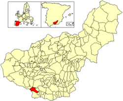
Otívar
This article needs additional citations for verification. (May 2024) |
Otívar, Spain | |
|---|---|
village | |
 Location of Otívar | |
| Country | Spain |
| Province | Granada |
| Municipality | Otívar |
| Area | |
• Total | 57 km2 (22 sq mi) |
| Population (2018)[1] | |
• Total | 1,029 |
| • Density | 18/km2 (47/sq mi) |
| Time zone | UTC+1 (CET) |
| • Summer (DST) | UTC+2 (CEST) |
Otívar is a municipality located at 267.80 metres above sea level in the Province of Granada, Spain. According to the 2004 census (INE), the village has a population of 1,113 inhabitants.
Agriculture is Otívar's predominant economic activity (mainly tropical fruit) however, due to the dramatic scenery of the surrounding mountains, a number of northern Europeans have discovered its charms and either take rural holidays here, or in a few cases have settled here and integrated with the local population. The Sierras of Tejeda, Almijara and Alhama Natural Park are just west of the town.
Otívar contains a cross between a subtropical micro climate and a coastal mediterranean climate, creating a perfect environment for the famous "Níspero" known in English as the "loquat". The average yearly temperature is 14.80 °C (degrees Celsius). In the warmer months the average temperature is 28,80 °C (degrees Celsius) and in the colder months the average temperature is 4,50 °C (degrees Celsius).
The current mayor is Francisco Robles Carrascosa, from the political party of PP. This is the second consecutive term the mayor has won, after the PSOE´s defeat four years ago.
See also
[edit]References
[edit]- ^ Municipal Register of Spain 2018. National Statistics Institute.


