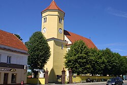
Przemków
Przemków | |
|---|---|
 Baroque Church of the Assumption | |
| Coordinates: 51°31′N 15°48′E / 51.517°N 15.800°E | |
| Country | |
| Voivodeship | Lower Silesian |
| County | Polkowice |
| Gmina | Przemków |
| Established | 1280 |
| Founded by | Przemko of Ścinawa |
| Named for | Przemko of Ścinawa |
| Government | |
| • Mayor | Jerzy Szczupak |
| Area | |
• Total | 5.64 km2 (2.18 sq mi) |
| Highest elevation | 132 m (433 ft) |
| Lowest elevation | 113 m (371 ft) |
| Population (2019-06-30[1]) | |
• Total | 6,107 |
| • Density | 1,100/km2 (2,800/sq mi) |
| Time zone | UTC+1 (CET) |
| • Summer (DST) | UTC+2 (CEST) |
| Postal code | 59 – 170 |
| Car plates | DPL |
| Climate | Dfb |
| National roads | |
| Voivodeship road | |
| Website | http://www.przemkow.pl/ |
Przemków [ˈpʂɛmkuf] (German: Primkenau) is a town in Polkowice County, Lower Silesian Voivodeship, in western Poland. It is the seat of the administrative district called Gmina Przemków. The town lies approximately 19 kilometres (12 mi) west of Polkowice, and 97 kilometres (60 mi) northwest of regional capital Wrocław.
As of 2019, the town has a population of 6,107.
Przemków gives its name to the nearby protected area called Przemków Landscape Park.
History
[edit]Przemków was initially a Polish trade settlement, which was granted town rights in 1280 by Duke Przemko of Ścinawa from the Piast dynasty and named after him.[2] In the past, it was also known in Polish as Przemkowo or Przymkowo.[3][4]
Two labour camps of the Reich Labour Service were operated in the town under Nazi Germany.[5]
Demographics
[edit]
|
| ||||||||||||||||||||||||||||||
| Source: [6][7] | |||||||||||||||||||||||||||||||
Cuisine
[edit]The officially protected traditional food of Przemków, as designated by the Ministry of Agriculture and Rural Development of Poland, is the Przemków honey gingerbread.[8]
Notable people
[edit]- Adolf Ernst (1832–1899), scientist
- Albert, Duke of Schleswig-Holstein (1869–1931), died at the palace
- Ernst Gunther, Duke of Schleswig-Holstein (1863–1921), died at the palace
References
[edit]- ^ "Population. Size and structure and vital statistics in Poland by territorial division in 2019. As of 30th June". stat.gov.pl. Statistics Poland. 2019-10-15. Retrieved 2020-02-14.
- ^ Orzechowski, Kazimierz; Przybytek, Dariusz; Ptak, Marian (2008). Dolny Śląsk. Podziały terytorialne od X do XX wieku (in Polish). Wrocław. p. 196. ISBN 978-83-923255-5-0.
{{cite book}}: CS1 maint: location missing publisher (link) - ^ Leksykon Polactwa w Niemczech (in Polish). Opole: Związek Polaków w Niemczech. 1939. p. 636.
- ^ Damrot, Konstanty (1896). Die älteren Ortsnamen Schlesiens, ihre Entstehung und Bedeutung. Mit einem Anhange über die schlesisch-polnischen Personennamen. Beiträge zur schlesischen Geschichte und Volkskunde (in German). Verlag von Felix Kasprzyk. p. 78.
- ^ "X Niederschlesien" (in German). Retrieved 11 November 2023.
- ^ Dokumentacja Geograficzna (in Polish). Vol. 3/4. Warszawa: Instytut Geografii Polskiej Akademii Nauk. 1967. p. 40.
- ^ Stan i struktura ludności oraz ruch naturalny w przekroju terytorialnym w 2010 r. (PDF) (in Polish). Warszawa: Główny Urząd Statystyczny. 2011. p. 49. Archived from the original (PDF) on 13 November 2011.
- ^ "Miodowe pierniczki z Przemkowa". Ministerstwo Rolnictwa i Rozwoju Wsi - Portal Gov.pl (in Polish). Retrieved 11 November 2023.


