Rousset, Bouches-du-Rhône
You can help expand this article with text translated from the corresponding article in French. (December 2008) Click [show] for important translation instructions.
|
Rousset | |
|---|---|
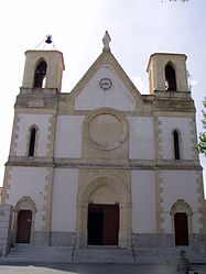
 The church of Rousset | |
| Coordinates: 43°28′52″N 5°37′19″E / 43.481°N 5.622°E | |
| Country | France |
| Region | Provence-Alpes-Côte d'Azur |
| Department | Bouches-du-Rhône |
| Arrondissement | Aix-en-Provence |
| Canton | Trets |
| Intercommunality | Aix-Marseille-Provence |
| Government | |
| • Mayor (2020–2026) | Jean-Louis Canal[1] |
Area 1 | 19.50 km2 (7.53 sq mi) |
| Population (2022)[2] | 5,357 |
| • Density | 270/km2 (710/sq mi) |
| Time zone | UTC+01:00 (CET) |
| • Summer (DST) | UTC+02:00 (CEST) |
| INSEE/Postal code | 13087 /13790 |
| Elevation | 196–480 m (643–1,575 ft) (avg. 224 m or 735 ft) |
| 1 French Land Register data, which excludes lakes, ponds, glaciers > 1 km2 (0.386 sq mi or 247 acres) and river estuaries. | |
Rousset (French pronunciation: [ʁusɛ]; Occitan: Rosset) is a commune in the Bouches-du-Rhône department in southern France close to Aix-en-Provence.
History
[edit]Although Rousset can be traced back to the Romans, the first written mention comes in a 1050 document, under the name of "Rosselun" or "roscetum rosetum".[3] In the Middle Ages, a castle as well as a church and chapels were built, as dwellings increased.[3]
In the 9th century, Rousset belonged to the Abbey of Saint-Victor,[3] then by 1143 the Knights Templar took over,[3] followed by the Knights of Malta in 1307.[3] In the 15th century, it belonged to Guillaume de Littera (1371-1452).[4]
Under the French Revolution, the castle was destroyed.[3]
The church was built in 1861.[3]
It is now home to a semiconductor fab and research center of STMicroelectronics and until 2014 also of another fab of LFoundry (originally set up by Atmel)
Cross of Provence
[edit]The fourth Croix de Provence on the Montagne Sainte-Victoire was erected in 1875, on the initiative of the parish priest of Rousset, Father Meissonnier, to ward off two evils: smallpox and the aftermath of the Franco-Prussian war of 1870.[5]
Population
[edit]
|
| ||||||||||||||||||||||||||||||||||||||||||||||||||||||||||||||||||||||||||||||||||||||||||||||||||||||||||||||||||
| Source: EHESS[6] and INSEE (1968-2017)[7] | |||||||||||||||||||||||||||||||||||||||||||||||||||||||||||||||||||||||||||||||||||||||||||||||||||||||||||||||||||
Twin towns
[edit]See also
[edit]References
[edit]- ^ "Répertoire national des élus: les maires" (in French). data.gouv.fr, Plateforme ouverte des données publiques françaises. 4 May 2022.
- ^ (in French). The National Institute of Statistics and Economic Studies. 19 December 2024 https://www.insee.fr/fr/statistiques/8288323?geo=COM-13087.
{{cite web}}: Missing or empty|title=(help) - ^ a b c d e f g h Site Officiel de la Mairie de Rousset sur Arc
- ^ Aix-en-Provence Historical Society: Guillaume de Littera
- ^ The Cross of Provence (La croix de Provence), in Sainte-Victoire, éd. Édisud / Association for reforestation and protection of Cengle-Sainte-Victoire, Aix-en-Provence, 1998, p. 93.
- ^ Des villages de Cassini aux communes d'aujourd'hui: Commune data sheet Rousset, EHESS (in French).
- ^ Population en historique depuis 1968, INSEE
External links
[edit]


