Skødstrup
Appearance
(Redirected from UN/LOCODE:DKSKT)
Skødstrup | |
|---|---|
Neighborhood | |
 | |
| Coordinates: 56°15′44″N 10°18′05″E / 56.262128°N 10.301322°E | |
| Country | Kingdom of Denmark |
| Regions of Denmark | Central Denmark Region |
| Municipality | Aarhus Municipality |
| District | Skødstrup |
| Population | |
• Total | 10,000 |
| Postal code | 8541 |
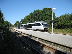
Skødstrup is a suburb located north-east of Aarhus in Denmark. The suburb is also a railway town at Grenaabanen, the railroad between the cities of Aarhus and Grenaa. Today Skødstrup has grown together with the adjoining railway town of Løgten into a small urban area named Løgten-Skødstrup with a population of 8,197 (1 January 2019).[1]
Skødstrup elementary school has more than 1250 students making it one of the largest schools in the region.
References
[edit]- ^ BEF44: Population 1 January, by urban areas database from Statistics Denmark
External links
[edit]Wikimedia Commons has media related to Skødstrup.
56°15′44″N 10°18′05″E / 56.262128°N 10.301322°E


