Al Wukair
Al Wukair
اَلْوُكَيْر | |
|---|---|
Town | |
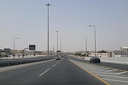
 Entrance to Al Wukair on Al Wukair Road. | |
| Coordinates: 25°09′03″N 51°32′16″E / 25.15083°N 51.53778°E | |
| Country | |
| Municipality | Al Wakrah Municipality |
| Zone | Zone 91 |
| Area | |
• Total | 25.55 km2 (9.86 sq mi) |
| Elevation | 9 m (30 ft) |
| Population (2004) | |
• Total | 4,400 |
| • Density | 170/km2 (450/sq mi) |


Al Wukair (Arabic: اَلْوُكَيْر) is a town in Qatar, located in Al Wakrah Municipality.[2] It is 19 minutes away from Doha and is located near the city of Al Wakrah. It was previously a prominent fishing and pearling village.[3] It was demarcated in 1988.[4] The gated compounds of Ezdan Village house a substantial part of the town's population.[5]
Etymology
[edit]Similar to neighboring Al Wakrah City, the town's name originates from the Arabic term "wakar", meaning bird's nest. This name was acquired from the abundant birds' nests in the area.[5]
Geography
[edit]Qatar's capital, Doha, is located at a distance of 23 km to the north. Other distances include Al Wakrah – 8 km to the east, Umm Salal Ali – 50 km to the north, Madinat ash Shamal – 130 km away, Al Khor – 80 km away, Mesaieed – 18 km away, and Dukhan – 66.5 km away.[6]
Developments
[edit]In 2015, construction began on a housing village for laborers located on a 150,000 sq meter plot of land in Al Wukair.[7]
The Public Works Authority (Ashghal) embarked on a QR 1.5 billion in Al Wukair South in April 2018, with an estimated completion date of 2020. Among the infrastructural improvements will be an additional 166 km of sewage networks, 310 km of water networks, 172 km of roads and a total of 27 intersections. Buildings to be constructed over a 15.5 square km area include 3,508 housing plots, 16 schools, 32 mosques, 1 hospital and several government and commercial plots.[8]
Industry
[edit]Al Wukair Logistics Park was built here on an area of 1.48 km2. The location was selected due to Al Wukair's close proximity to the major highway system of Al Majd Road and Qatar's main seaport, Hamad Port. Warehouses in the park will be maintained by GWC (Gulf Warehousing Company QPSC) and will have a variety of specialized storage facilities. Other industrial facilities in the park will include warehouse yards and light industrial workshops. Furthermore, the park will host a mosque, laborers' residences and stores.[9]
Transport
[edit]The community is served by two metrolinks, a feeder bus network, from Al Wakrah Metro Station:[10]
- M130, which serves Ezdan Village 4–7.
- M131, which serves Ezdan Village 3 and 8–11.
Demographics
[edit]| Year | Population |
|---|---|
| 1986[11] | 4,141 |
| 1997[12] | 3,948 |
| 2004[13] | 4,400 |
References
[edit]- ^ "Al Wukair, Zone 91, Qatar on the Elevation Map". elevationmap.net. Retrieved 14 January 2019.
- ^ "2010 population census" (PDF). Qatar Statistics Authority. Archived from the original (PDF) on 2 April 2015. Retrieved 2 July 2015.
- ^ "Introducing Al-Wakrah & Al-Wukair". Lonely Planet. Retrieved 2 June 2015.
- ^ "Law No. 18 of 1988 On the Delimitation of the City of Al Wukayer". almeezan.qa. Retrieved 29 July 2015.
- ^ a b "District map". The Centre for Geographic Information Systems of Qatar. Archived from the original on 20 November 2022. Retrieved 4 January 2019.
- ^ "Qatar in Figures" (PDF). Ministry of Development Planning and Statistics. 2015. p. 9. Archived from the original (PDF) on 13 May 2017. Retrieved 7 July 2018.
- ^ Peter Kovessy (12 March 2015). "Housing 'village' for thousands of Qatar workers planned in Wukair". Doha News. Retrieved 2 June 2015.
- ^ Irfan Bukhari (4 April 2018). "Ashghal signs contracts to develop Al Wukair South". The Peninsula. Retrieved 29 June 2018.
- ^ "Al Wukair". Manateq. Retrieved 14 May 2019.
- ^ "Metrolink". Qatar Rail. Retrieved 6 December 2019.
- ^ "1986 population census" (PDF). Qatar Statistics Authority. Archived from the original (PDF) on 3 July 2015. Retrieved 2 July 2015.
- ^ "1997 population census" (PDF). Qatar Statistics Authority. Archived from the original (PDF) on 29 May 2015. Retrieved 2 July 2015.
- ^ "2004 population census". Qatar Statistics Authority. Archived from the original on 24 September 2015. Retrieved 2 July 2015.

