Badulla District
Badulla District
බදුල්ල දිස්ත්රික්කය பதுளை மாவட்டம் | |
|---|---|
 Tea plantation in Haputale | |
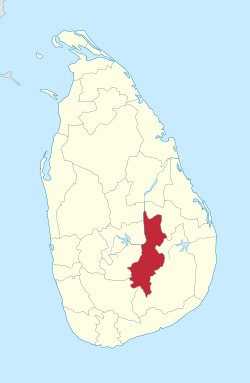
 Map of Sri Lanka with Badulla District highlighted | |
 Map of Badulla district showing its administrative areas | |
| Coordinates: 6°59′05″N 81°03′23″E / 6.98472°N 81.05639°E | |
| Country | Sri Lanka |
| Province | Uva Province |
| Largest City | Badulla |
| Divisions | List
|
| Government | |
| • District Secretary | Damayanthi Paranagama |
| Area | |
• Total | 2,861 km2 (1,105 sq mi) |
| Population (2011) | |
• Total | 886,000 |
| • Density | 310/km2 (800/sq mi) |
| Time zone | UTC+05:30 (Sri Lanka) |
| ISO 3166 code | LK-81 |
| Languages | Sinhala, Tamil, English |
| Website | ds.gov.lk/dist_badulla |


Badulla District (Sinhala: බදුල්ල දිස්ත්රික්කය badūlla distrikkaya; Tamil: பதுளை மாவட்டம் Patuḷai māvaṭṭam) is a district in Uva Province, Sri Lanka. The entire land area of the Badulla district is 2,861 km2 (1,105 sq mi) and has a total population of 837,000.[when?] The district is bounded by the Kandy district to the North and by Nuwara Eliya and Matale districts to the West. The South-Eastern border creates with the districts of Rathnapura,Monaragala & Ampara. Mainly the economy of the district is based on agricultural farming and livestock.
Badulla District is an agricultural district where tea and various vegetables are cultivated. The district is divided into an upper region and a lower region which differ in climatic and geographic characteristics. The upper region of the district is known for tea plantations and vegetable cultivation while the lower region focuses more on paddy farming.[1][2]
Education
[edit]Universities
[edit]Schools
[edit]Bandarawela
- Bandarawela Central College
- S. Thomas' College, Bandarawela
- St.Joseph's college
- Bandarawela Tamil Central College
Badulla
- Dharmadutha College
- Uva College
- Badulla Central College
- Vishaka Girls High School
- Viharamahadevi Girls School
Mahiyanganaya
- Mahiyanganaya National school
Passara
- Passara National College
- Passara Tamil Maha Vidyalayam National College
- Sri Ramakrishna College
- Al Adhan Maha Vidyalaya
- Barathy Maha Vidyalayam
- Tamils Girls maha vidyalayam
- Gonakelle Tamil Maha Vidiyalayam
welimada
- Welimada Central Collage
Electorate divisions in Badulla District
[edit]- Badulla
- Bandarawela
- Hali-Ela
- Haputale
- Mahiyanganaya
- Passara
- Uva-Paranagama
- Welimada
- Wiyaluwa
Major cities
[edit]- Badulla (Municipal Council)
- Bandarawela (Municipal Council)
Major towns
[edit]- Haputale (Urban Council)
Other places
[edit]- Mahiyanganaya
- Diyatalawa
- Hali-Ela
- Ella
- Haldummulla
- Beragala
- Welimada
- Kandaketiya
- Meegahakivula
- Passara
- Lunugala
- Tennapanguwa
- Kumarapattiya
Demography
[edit](2010 estimates 887220)
Religion
[edit]Religion in Badulla District (2011)[3]
| Religions | |||
|---|---|---|---|
| Buddhism | 589,393 | (72.63%) | |
| Hinduism | 157,360 | (19.39%) | |
| Islam | 47,172 | (5.81%) | |
| Roman Catholic | 11,630 | (1.43%) | |
| Other Christian | 5985 | (0.74%) | |
Important locations in Badulla District
[edit]- Mahiyangana Raja Maha Vihara
- Muthiyangana Raja Maha Vihara, Badulla
- Army Garrison Town, Diyatalawa
- Namunukula Mountain Range
- Lipton's Seat and Adisham Bungalow in Haputale
- Railway bridge and Railway line in Demodara
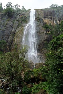
- Dunhinda, Babarakanda, Diyaluma and Ravana Ella Waterfalls
- Bogoda Wooden Bridge
- Indigenous Vedda people, Dambana
See also
[edit]References
[edit]- ^ "Uva Province" (PDF). Archived from the original (PDF) on 2010-11-13. Retrieved 2010-03-19.
- ^ "Uva". Archived from the original on 2011-06-05. Retrieved 2010-03-19.
- ^ Department of Census and Statistics,The Census of Population and Housing of Sri Lanka-2011
