Kenardington
| Kenardington | |
|---|---|
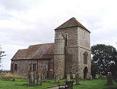
 Church of St Mary, Kenardington | |
Location within Kent | |
| Area | 7.47 km2 (2.88 sq mi) |
| Population | 283 (Civil Parish 2021)[1] |
| • Density | 38/km2 (98/sq mi) |
| OS grid reference | TQ972330 |
| Civil parish |
|
| District | |
| Shire county | |
| Region | |
| Country | England |
| Sovereign state | United Kingdom |
| Post town | Ashford |
| Postcode district | TN26 |
| Dialling code | 01233 |
| Police | Kent |
| Fire | Kent |
| Ambulance | South East Coast |
| UK Parliament | |
Kenardington is a small clustered village and the centre of a relatively small rural civil parish of the same name, in the Ashford District of Kent, England. The village is centred 8 miles (13 km) southwest of Ashford on the B2067 Hamstreet to Tenterden road.
Geography
[edit]Kenardington is on the edge of Romney Marsh, which its church of St Mary (with its tower dated 1170 AD) overlooks from a hilltop. The site of the church was once the scene of a battle, being stormed by the Danes in the 10th century and it stands on the site of what seems to have been a small Saxon fort, the remains of its earthworks now largely ploughed out of sight in fields used as arable land.
Amenities and long distance tour routes
[edit]Kenardington had a village shop/post office until a date in the 1980s since which the nearest shops and railway station are in Hamstreet approximately two miles away. The south-west of the parish is a wooded public park and has picnic areas.
The Saxon Shore Way and Royal Military Canal pass through.
References
[edit]External links
[edit]![]() Media related to Kenardington at Wikimedia Commons
Media related to Kenardington at Wikimedia Commons

