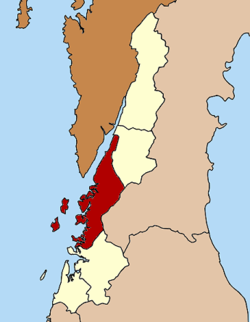
Mueang Ranong district
Mueang Ranong
เมืองระนอง | |
|---|---|
 Phu Khao Ya landmark and local attraction | |
 District location in Ranong province | |
| Coordinates: 9°58′2″N 98°38′2″E / 9.96722°N 98.63389°E | |
| Country | Thailand |
| Province | Ranong |
| Seat | Khao Niwet |
| Area | |
• Total | 713.7 km2 (275.6 sq mi) |
| Population (2023)[1] | |
• Total | 93,271 |
| • Density | 130/km2 (300/sq mi) |
| Time zone | UTC+7 (ICT) |
| ISO 3166 code | TH-8501 |
| Postal code | 85000 |
| Sai Daeng | 85130 |
Mueang Ranong (Thai: เมืองระนอง) is the capital district (amphoe mueang) of Ranong province, in southern Thailand.
Geography
[edit]Neighboring districts are (from the north clockwise) La-un of Ranong Province, Phato of Chumphon province, and Kapoe of Ranong. To the west across the Kraburi River estuary is the Tanintharyi Division of Myanmar.
Administration
[edit]Provincial government
[edit]The district is divided into nine subdistricts (tambons), which are further subdivided into 38 villages (muban).[1]
| No. | Subdistricts | Thai | Villages | Pop. |
|---|---|---|---|---|
| 1. | Khao Niwet | เขานิเวศน์ | - | 17,779 |
| 2. | Ratchakrut | ราชกรูด | 8 | 9,766 |
| 3. | Ngao | หงาว | 5 | 9,539 |
| 4. | Bang Rin | บางริ้น | 6 | 22,830 |
| 5. | Pak Nam | ปากน้ำ | 6 | 10,456 |
| 6. | Bang Non | บางนอน | 4 | 14,443 |
| 7. | Hat Som Paen | หาดส้มแป้น | 3 | 3,191 |
| 8. | Sai Daeng | ทรายแดง | 4 | 3,981 |
| 9. | Koh Phayam | เกาะพยาม | 2 | 1,286 |
| Total | 38 | 93,271 |
Local government
[edit]As of December 2023 there are two town municipalities (thesaban mueang), Ranong covers subdistrict Khao Niwet, while Bang Rin covers the whole subdistrict. Five subdistrict municipalities (thesaban tambon): Ngao, Pak Nam and Pak Nam Tha Ruea cover parts of the subdistricts Ngao and Pak Nam, while Bang Non and Ratchakrut cover the whole subdistrict. There are four subdistrict administrative organizations - SAO (ongkan borihan suan tambon): Ngao covers part of the subdistrict and Sai Daeng, Hat Som Paen and Koh Phayam cover the whole subdistricts.[1]
| Town municipality | Pop. | website |
|---|---|---|
| Bang Rin | 22,7830 | bangrin |
| Ranong | 17,779 | ranongcity |
| Subdistrict municipality | Pop. | website |
|---|---|---|
| Bang Non | 14,443 | bangnoncity |
| Ratchakrut | 9,766 | ratchakrudcity |
| Pak Nam Tha Ruea | 8,071 | paknamtarua |
| Ngao | 2,399 | ngaotown-ranong |
| Pak Nam | 2,385 |
| Subdistrict adm.org-SAO | Pop. | website |
|---|---|---|
| Ngao | 7,140 | ngao-ranong |
| Sai Daeng | 3,981 | saidang |
| Hat Som Paeng | 3,191 | hatsompaen |
| Koh Phayam | 1,286 | kohphayam |

