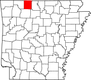
Prairie Township, Boone County, Arkansas
Appearance
Prairie Township | |
|---|---|
| Coordinates: 36°9′19.06″N 92°54′54.74″W / 36.1552944°N 92.9152056°W | |
| Country | |
| State | |
| County | Boone |
| Area | |
• Total | 16.272 sq mi (42.14 km2) |
| • Land | 16.266 sq mi (42.13 km2) |
| • Water | 0.006 sq mi (0.02 km2) |
| Population (2010) | |
• Total | 444 |
| • Density | 27.36/sq mi (10.56/km2) |
| Time zone | UTC-6 (CST) |
| • Summer (DST) | UTC-5 (CDT) |
| Zip Code | 72633 (Everton) |
| Area code | 870 |
Prairie Township is one of twenty current townships in Boone County, Arkansas, USA.[1] As of the 2010 census, its total population was 444.
Geography
[edit]According to the United States Census Bureau, Omaha Township covers an area of 78.986 square miles (204.57 km2); 77.985 square miles (201.98 km2) of land and 1.001 square miles (2.59 km2) of water.
Cities, towns, and villages
[edit]Population history
[edit]Figures below include the population of the incorporated town of Everton.
| Census | Population |
|---|---|
| 2010 | 444 |
| 2000 | 487 |
| 1990 | 436 |
| 1980 | 433 |
| 1970 | 367 |
| 1960 | 348 |
| 1950 | 503 |
| 1940 | 579 |
| 1930 | 530 |
| 1920 | 721 |
| 1910 | 670 |
| 1900 | 500 |
| 1890 | 617 |
| 1880 | 667 |
| 1870 | 1,214 |
| 1860 (area part of Carroll County at the time) | 1,205 |
| 1850 (area part of Carroll County at the time) | 1,131 |
References
[edit]- United States Census Bureau 2008 TIGER/Line Shapefiles
- United States Board on Geographic Names (GNIS)
- United States National Atlas
- ^ "Prairie Township, Boone County, Arkansas." U.S. Census Bureau. Breakdown. Retrieved June 2, 2012.


