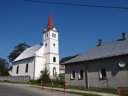
Výborná
Výborná | |
|---|---|
Municipality | |
 | |
| Coordinates: 49°14′00″N 20°23′45″E / 49.23333°N 20.39583°E | |
| Country | Slovakia |
| Region | Prešov |
| District | Kežmarok |
| Area | |
• Total | 10.54[2] km2 (4.07[2] sq mi) |
| Elevation | 701[3] m (2,300[3] ft) |
| Population (2021) | |
• Total | 1,351[1] |
| Time zone | UTC+1 (CET) |
| • Summer (DST) | UTC+2 (CEST) |
| Postal code | 059 02[3] |
| Area code | +421 52[3] |
| Car plate | KK |
| Website | http://www.obecvyborna.sk |
Výborná (Hungarian: Sörkút, German: Bierbrunn, Rusyn: Віборна) is a village and municipality in Kežmarok District in the Prešov Region of north Slovakia.[5]
History
[edit]In historical records the village was first mentioned in 1289. Before the establishment of independent Czechoslovakia in 1918, Výborná was part of Szepes County within the Kingdom of Hungary. From 1939 to 1945, it was part of the Slovak Republic. On 27 January 1945, the Red Army dislodged the Wehrmacht from Výborná in the course of the Western Carpathian offensive and it was once again part of Czechoslovakia.
Demographics
[edit]The majority of the municipality's population consists of the members of the local Roma community. In 2019, they constituted an estimated 86% of the population.[6]
Geography
[edit]The municipality lies at an altitude of 706 metres and covers an area of 10.544 km² . It has a population of about 1070 people.
External links
[edit]References
[edit]- ^ "Počet obyvateľov podľa pohlavia - obce (ročne)". www.statistics.sk (in Slovak). Statistical Office of the Slovak Republic. 2022-03-31. Retrieved 2022-03-31.
- ^ a b "Hustota obyvateľstva - obce [om7014rr_ukaz: Rozloha (Štvorcový meter)]". www.statistics.sk (in Slovak). Statistical Office of the Slovak Republic. 2022-03-31. Retrieved 2022-03-31.
- ^ a b c d "Základná charakteristika". www.statistics.sk (in Slovak). Statistical Office of the Slovak Republic. 2015-04-17. Retrieved 2022-03-31.
- ^ a b "Hustota obyvateľstva - obce". www.statistics.sk (in Slovak). Statistical Office of the Slovak Republic. 2022-03-31. Retrieved 2022-03-31.
- ^ "Statistical Office of the Slovak Republic" (PDF). Výsledky SODB 2011. Štatistický úrad SR. Archived from the original (PDF) on October 12, 2013. Retrieved 9 August 2012.
- ^ Ábel Ravasz, Ľuboš Kovács and Filip Markovič, Atlas rómskych komunít 2019. Bratislava: Veda, 2020, ISBN 978-80-224-1874-4, database appendix available at: https://www.institutmatejabela.sk/atlas.

